Rhiza is a new digital agronomy platform that appears to bring a remarkable array of data within easy reach of the precision farming novice. CPM talks to the team behind it and takes it for a test drive.
What startled me was the amount of data most farmers are sitting on.
By Tom Allen-Stevens
You may not even realise it, but you could be at the vanguard of agriculture’s fourth revolution.
A new digital agronomy brand has been launched – Rhiza. It brings together two UK precision agriculture services, SoilQuest and IPF, which have more than 15 years of experience in the sector, both now owned by Origin Enterprises. Rhiza offers farmers and agronomists a new suite of tools that promises to bring digital agronomy “from satellite to soil to seed to crop”.
On the face of it, this will hardly raise an eyebrow with most arable farmers who have already witnessed a raft of digital developments, but remain unconvinced of their benefits. They may also be slightly daunted at the prospect of a possible pursuit of catch-up with the precision enthusiasts already sitting on vast arrays of geo-referenced data amassed over years of investment in digital technology systems.
But these are the very farmers Rhiza is set to appeal to, believes Simon Beck, Origin’s head of digital. “Digital agronomy is far broader and more affordable than the precision farming systems it has, until now, mainly been associated with,” he says.

Rhiza promises to bring digital agronomy from satellite to soil to seed to crop.
“In its simplest form, our system merely involves logging and automatically transferring geo-referenced field-walking observations to your farm records,” he points out. For this you need just a phone or tablet with GPS and the Contour app, which is free to download. It can be used to record and share information and pictures on areas of interest or concern so you can target management action throughout the season. Once recorded, they can be related to field performance and, if available, yield maps to plan future changes.
“If you want further benefits with Rhiza you can, at any stage, add optical satellite imagery to give you a ‘health report’ of every part of every field; radar-derived crop growth monitoring and yield predictions; weather-based local pest and disease modelling; access to an ever-increasing library of precision farming and R&D; and sophisticated soil mapping and variable rate management tools to make the most of precision farming.”
But Simon recognises that such gadgetry isn’t in itself likely to appeal to the majority of growers – it’s what lies behind Rhiza that may reveal its true value. “On its own, a digital tool is just that. What Origin wraps around Rhiza is its service and R&D back-up. Here we’re not talking about just a few split-field trials, but 15-16 years’ worth of industry-leading agronomy evaluation and in-field experience.”
Origin itself is an organisation, based in Dublin, with €1.6bn annual revenues operating exclusively in agri-services across Europe and Latin America. In the UK, it’ll be most familiar to growers as the owner of Agrii, aside from its range of fertilisers. The plan for Rhiza is that it’s the platform, not just for the digital tools through IPF and Soilquest, but for R&D testimonial, decision support, iFarms back-up and other science that provide the engine of Agrii’s agronomy advice.
It was a journey started two and a half years ago when Simon joined Origin to develop its digital strategy. His background is in business and technology, having worked in companies such as Dell helping large organisations take on a digital infrastructure that sets them up for the modern world of business.
“Essentially we were installing computing hardware, but that’s just the tool. You need all the people in the organisation to deliver the outcomes that tool enables – it’s not about the technology available to buy but the problems you want to solve,” he says.
With Origin, the priorities have been to work with farmers to increase yields, return on investment and profitability, and the place to start for Simon, who’d never worked in agriculture before, was the data available. “What startled me was the amount of data most farmers are sitting on. I was also surprised that, for the most part, large tech companies had completely ignored such a significant sector of the economy.”
In farming, just like the big organisations Simon was used to, this data is held in “silos”, not shared with others and put to good use. “The challenge for all businesses is how you use the data you have – how do you sift through it to inform everyday decisions? There are very clear similarities in farming, but there’s also the opportunity to look up and down the supply chain. There’s value in data shared with grain traders, financial lenders and other actors.”
Data ownership becomes important, he notes. “The person who creates the data owns it. It should be up to the farmer to elect people with whom they share their data – this shouldn’t be assumed. But there are now standard platforms where data is shared and you set permissions, so the functionality is there.”
The other challenge is the “silos” that hold the data. Simon recognises that Rhiza needs to integrate with crop recording packages such as Gatekeeper and Muddy Boots. “There are problems associated with integrating with legacy systems, but it’s an issue the whole industry is addressing. It’ll happen, but we’re not there yet. What’s more, it’s been conquered in other industries, so it’s not unsurmountable.”
But the over-riding aim for Rhiza is to provide farmers with a tool of value from the first day they register – you don’t need to bring years of existing data, nor layers of yield maps and other precision farming information, into the platform to get some useful information that will help everyday decisions.
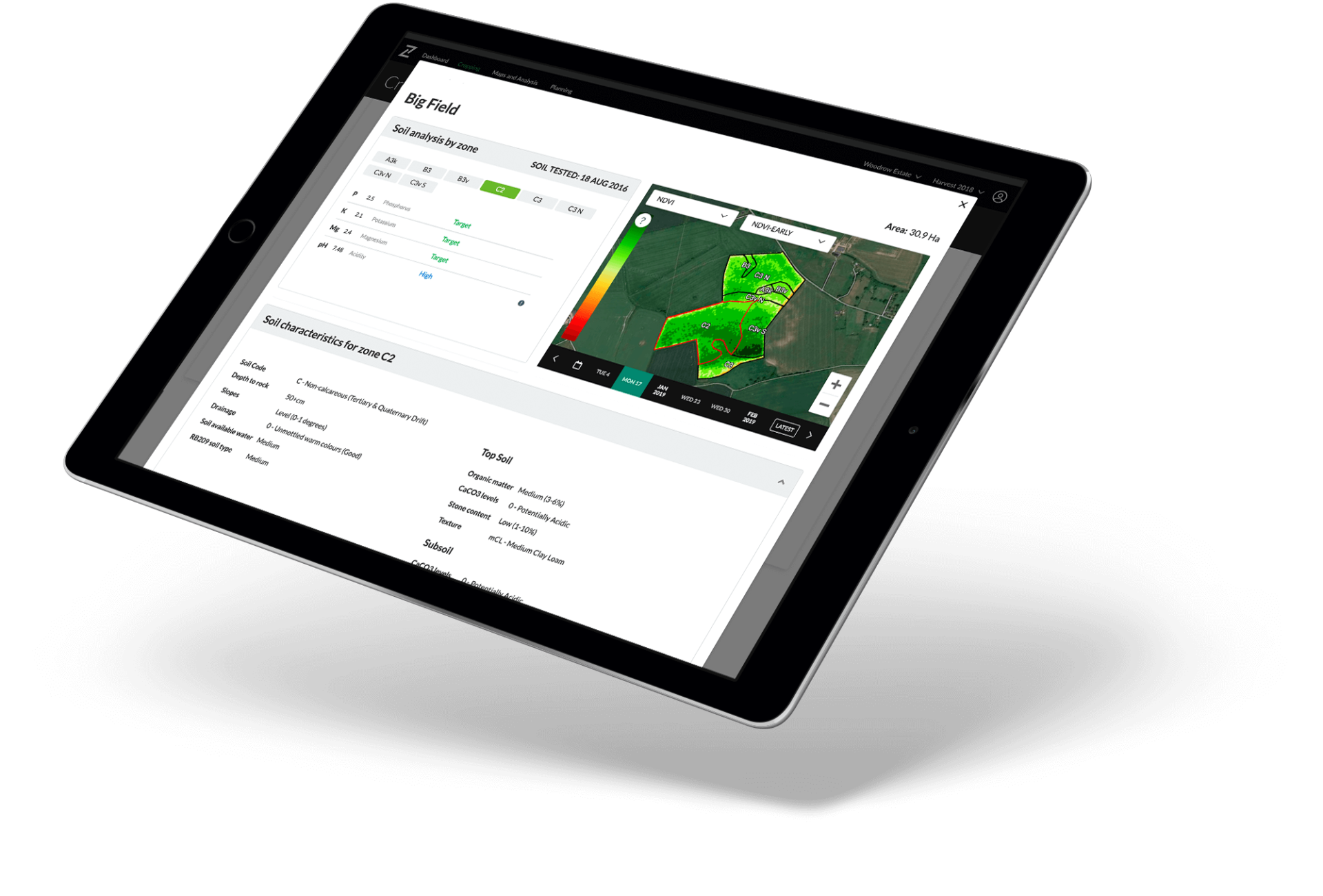
An example is soil data – an investment of over £1M has enabled Rhiza, working with Cranfield University and James Hutton Institute, to create what the project team behind it claims is the UK’s first precision soil map. This data can be viewed in Contour, as a low-cost alternative to a soil scientist or soil scanner visiting the field.
The satellite-generated information is also unique to Rhiza, says Simon. “It pulls in data of the highest resolution (3.5m²) and best frequency available.” This includes SAR (Synthetic Aperture Radar) data. The satellite effectively sees the crop in 3D and overcomes one of the limitations of satellite-derived data, that your fields can’t be seen on a cloudy day, as the radar penetrates the cloud layer. This also gives Rhiza the ability to measure crop biomass, and ultimately forecast yield.
There’s also Rhiza’s septoria-forecasting tool. “It’s based on many years of trials and pulls in weather information specific to your farm – both historic and forecast five days – to give you an accurate idea of risk in your crop,” says Simon.
The plan is that Rhiza becomes the tool through which farmer and agronomist base agronomy decisions – as well as the septoria tool, there’s a BYDV-risk tool, and there are plans to build in Agrii’s other R&D work, says head of technical Clare Bend. This includes the extensive fungicide trials and the many years’ work on blackgrass undertaken at its site in Stow Longa.
“When it comes to septoria resistance, with chlorothalonil falling away, anything that will help growers move to a well informed protectant mode with their fungicide strategy will pay dividends,” she says.
Origin is also the business partner in a major research project underway at University College Dublin. CONSUS is a €17.6M (£15M) programme over 5 years, jointly funded by Science Foundation Ireland, that aims to deliver the next generation of digital tools.
“There are nine work packages,” explains Simon. “The first three look at computer science, taking large datasets and using machine learning and artificial intelligence to investigate the art of the possible.”
Another three work packages look at plant science – root establishment, the impact of soil compaction, seed treatments, nematicides, and how choice of variety makes a difference. “The last three packages bring this information together, to help farmers make decisions in the field – we’re getting to realise that developing the right decision-support tool lies at the heart of the challenge.”
Rhiza is already in use on over 500,000ha across the country, and there are three main starting levels of service – Base, Plus and Pro. The Base version brings you boundary mapping, georeferenced cropping, hyperlocal weather, and the Contour mobile app. The Plus service adds optical satellite imagery to this and costs the equivalent of just over 7kg/ha of ammonium nitrate at today’s prices, claims Simon. “Even with the addition of crop growth modelling, yield predictions and pest and disease decision support tools, the Pro service needs a feed wheat yield increase of just 20kg/ha to pay for it.”
He’s confident Rhiza will play its part to help farmers usher in the fourth agricultural revolution. “I’ve been blown away by the amount of data in the farming industry and the sophistication of the technology now available to harness it. The perception is that farmers are reluctant to progress. I think it’s just they’re unaware of the potential of the tools and the information they now have to build a truly sustainable agriculture, using the best science and an evidence-based approach.”
Beginners guide to a digital future
So what’s Rhiza like to use? The Contour platform was actually launched last year and has been in use by existing IPF and SoilQuest customers, as well as new users who have come on board. A growing number of agronomists are also integrating its use into their day-to-day activities, reports Rhiza business manager Max Dafforn.
“There’s a lot than Rhiza can do,” he says. “The key over the past year has been tweaking the platform, picking out the essential bits of information our feedback suggests farmers find most useful, and presenting these in a way that’s easy to use.”
The septoria widget is the all-new feature that takes a prominent position on the dashboard as you open the software. A dial gives you an at-a-glance idea of what the current risk status is. Click on this and you’re taken to a chart that tracks what the risk has been over the past four weeks and for five days forward.
“One feature that’s proved popular is the ability to overlay current weather data, or some other criteria, with the same period last year. Many growers like to compare rainfall data, while YEN growers find information on solar radiation particularly useful.”
On the maps and analysis tab, a new ribbon along the bottom of the window indicates dates when a satellite flew over your farm, with a weather icon indicating cloud cover on the day, and hence reliability of data. This is then displayed as normalized difference vegetation index (NDVI) or green chlorophyll vegetation index (GCVI). Up to four windows can be viewed at any one time on the same screen, so you can compare different years.
The Rhiza team can help you get set up and import your cropping plan from Gatekeeper. Then, provided you fill in details such as drilling date, an estimate of biomass and expected yield (from May onwards) is totted up for you.
“You’ll also be able to see any observations noted through the Contour app, marked as pins,” continues Max. “We’re getting some good feedback on the app, particularly on farms where spray operators or contractors use it to fill in georeferenced blackgrass patches, for example, that the agronomist can then look for – it’s an effective way to make use and capture the eyes and ears of the people who spend their time in your crops.”
He’s noticed agronomist confidence in the platform is growing, with more agronomists using it to help inform where they focus their attention. “It’s particularly useful for getting the most out of the time they spend on farm. Rhiza gives them a good indication of any trouble spots that may warrant closer scrutiny.”
But the biggest effect Max has noticed is that Rhiza’s brought a level of precision agronomy to farmers who wouldn’t ordinarily access it. “We’re moving away from precision farming in its traditional sense,” he says.
“Rhiza delivers a set of tools that are really easy to use for those who haven’t seen its benefits before, while it also caters for growers who now routinely use precision agronomy as part of their arable system. The difference here is that you register and can instantly access quite an impressive array of data about your crop that’s already been captured.”


