Farming’s growing focus on precision is behind CNH Industrial’s extension of its product offering beyond machinery into compatible technology. CPM gets exclusive insight.
It’s technology that will help users achieve greater performance from their equipment, greater efficiency, and greater certainty when making decisions.
By Martin Rickatson
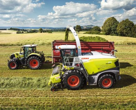
On a sunny September day, the latest farm equipment unveiling by a big-name tractor maker to a selected audience took place alongside a small country road in East Anglia. Yet even an agriculturally-minded passer-by would barely have batted an eyelid. The tractors trundling up and down the field looked no different to those currently available.
But the low-key, pan-European training event for the manufacturer’s staff was a significant pointer to the direction tractor makers – and specifically the firm in question – may be headed. A keener glance at the machines would have revealed the seemingly simple but significant additions and attachments to each tractor, ranging from a front-mounted boom to something resembling a high-tech front weight block. Despite those deceptive initial appearances, these are the tools CNH Industrial, and its brands including New Holland, plans to make a focal part of its offering through key dealers, alongside its tractors, combines, tillage equipment and other machinery.
“Since the concept of precision farming really took off at the beginning of the last decade, from a tractor point of view the biggest part of the business has been about guidance and auto-steering,” says John Downes, CNHi precision farming specialist.
“Today it represents about 80% of the precision farming business we do, but that proportion is falling steadily as farmers move to broaden their use of precision tools and supplement auto-steering with complementary technologies – systems such as data management software, telematics, rate controllers and others.
“We’re looking to expand the suite of connected precision farming solutions that our dealers can offer to fit with the way farming practices are developing, and we’ve been in discussion for some time now with a number of manufacturers about collaborating on our relevant areas of expertise. That’s led to the recent signing of agreements with four specialist firms in the sector, and New Holland exhibits at this year’s Tillage-Live event showed the direction in which our business is heading, with the unveilings of new products which will become part of the full-line product offering.”
The new precision farming equipment product range from selected CNHi dealers, which will be offered through New Holland dealerships under its Precision Land Management (PLM) banner, has been developed from a series of licensing agreements with key precision farming technology specialist firms. These include the front-mounted Crop Sensor boom from German firm Fritzmeier, which uses optical sensors to measure crop nitrogen need and alter accordingly the application rate of a rear-mounted fertiliser spreader. There is also a range of in-field sensor-to-smartphone technologies from Dutch firm SmartFarm, which deliver real-time data on weather, soil temperature and rainfall from field sensors to the user’s phone.
“We’re adding products to our range that will deliver genuine value to customers, by aiding their decision making and improving their accuracy,” says John.
“This is the next step in our precision farming technology offering. We’re working with selected dealers – those in key arable areas with dedicated precision farming product sales and support staff – to provide them with a complete suite of fully-supported precision equipment, with dealer personnel having received full training in its capabilities and set-up requirements.
“It’s technology that will complement our machinery offering, with the aim of helping users achieve greater performance from their equipment, greater efficiency in terms of return from inputs, and greater certainty when making decisions.”
Some of the equipment, such as the Crop Sensor, has been seen in the market before, but one piece of kit that hasn’t yet really made its mark is the Topsoil Mapper (TSM), made by Austrian firm Geoprospectors and previously available here through a specialist precision farming firm. Now it looks set for bigger push as it becomes part of the offering from CNHi’s farm equipment brands.
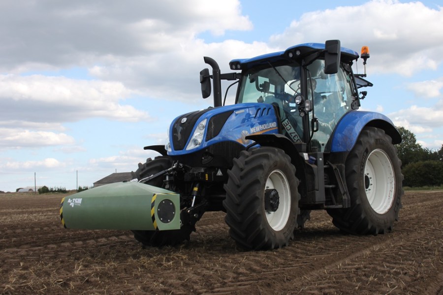
The innocuous-looking item resembles a large ballast block, but is made from plastic and weighs only around 35kg, and can be ordered in an alternative version that is incorporated into a front weight. It emits and receives electrical conductivity (EC) signals in much the same way as the established trailed scanners used by many precision farming mapping firms, its machine-mounted design is claimed to allow faster surveying of soils without any loss of accuracy. That potentially makes soil mapping something that could be offered by more than just specialist precision farming firms – large-scale arable contractors, for example – and also provides the instant data necessary to make possible on-the-move variable-depth cultivation.
EC correlates strongly to soil particle size and texture. With its larger particles and low water-holding capacity, the EC of sandy soil is low, while conversely that of clay and organic soils is high, and silts sit somewhere in between. EC signals are also an effective guide to topsoil depth and soil porosity, another aid to accurate mapping of different areas within a field.
With the unit working around 30cm above ground – front linkage mounting is the most common installation but others are possible – and plugged in to the tractor’s electrical system, the principle is that it passes over the land and works autonomously and coincidentally as the tractor is completing its primary intended task, such as soil loosening.
It’s possible to fit the TSM onto any suitable machine, from an ATV through to a combine. Control and monitoring are via a Windows 10-based tablet, although this displays only the measurement paths and points, rather than actual soil EC profile mapping as, suggests Geoprospectors, a driver studying a map as it is being formed will gain little immediately-valuable information. But whether being used for recording only or recording plus variable depth or application in response, TSM operation is completely autonomous.
The EC signals received back from the ground indicate the depth of topsoil and the soil’s porosity, with that having a greater porosity and depth more easily conducting electrical current and sending stronger waves back to the unit’s receiving coils. In this way, topsoil depth and porosity maps can be created.
Because the scanner is mounted above the ground rather than trailed along it, its field of coverage is wider than the unit alone, and depending on the height above ground at which it is operated – 30cm is recommended – it transmits and receives out to 1.5m each side of the implement, giving it a total span of approximately six metres, ensuring it can match the pass width of most soil-engaging implements. As it is mounted, it can also be operated at far faster forward speeds than a trailed unit without affecting accuracy or risking damage, suggests the maker.
In operation with a tractor, the driver mounts the device to the front linkage and connects it to the tractor’s electrical supply and the in-cab tablet controller. The unit is calibrated by raising and lowering it into its working position, and then its GPS position is verified – the system can work with any signal but the sub-2.5cm variation of RTK produces the most accurate maps. The operator then selects the job management tab on the operating screen and opens a new field job.
“The TSM is capable of producing two different data displays – one for those who are looking simply to map their soils, and a more advanced model for those wishing to link the data immediately to a variable depth cultivation system,” explains Geoprospectors’ Tibor Feher.
“In both modes, the mapper conducts autonomous measurements of the soil’s electrical conductivity without contacting the soil. The in-cab display simply shows the path and points across the field where readings are being taken. Maps with the soil parameters for compaction, type of soil and water saturation can then be created from the measured data by transfer in the field to a laptop, on which our Topsoil Data Analyser software can analyse automatically and display maps within a few seconds. This allows, for example, soil samples to be taken immediately and directly based on the zone maps determined on-site.
“Soil is measureable down to a depth of one metre, and in four layers to give an indication of relative density. This gives the user the ability to integrate this information with other data for farm management purposes, in order, for example, to generate soil testing, application or procedure maps – to show where subsoiling is required, for example.
“In Pro mode, the recording works in the same way as the Basic mode described, but the acquisition of the data and application of the remedial action are combined into one work step, as long as the tractor and implement have the necessary features to enable variable seed rate or variable depth control. A topsoil visualiser processes the recorded data to calculate compaction and water saturation values, and feeds data to compatible variable-working systems, such as a variable-depth system based on a potentiometer for cultivation equipment or a variable seed rate system for a drill. In this way, subsoilers automatically work more deeply in compacted areas, for example, while seed rates can be raised automatically in tough and/or dry zones.
“The TSM is the only soil sensor on the market that can be used in this manner, and with full ISOBUS Class III compatibility, it’s able to make possible true variable rate drilling on the move in real time according to variables such as soil type or moisture.”
Geoprospectors’ calculations suggest that as a general average figure a saving of 6-7 litres/ha of fuel is possible by using variable depth cultivation to loosen deeply only where identifiably necessary. A potential 20% reduction in working time per ha is also claimed from an increased workrate, as is a reduction in working metal and general machine wear.
Further potential benefits, suggests the company, include the identification of areas within fields warranting individual attention, the ability to identify the thickness of the soil layer permeable by roots, in order to target soil improvement measures, and the ability to map for targeted irrigation. And the firm claims compatibility with other farm management software means overlaying of map data with yield maps, green area index maps and suchlike should not be an issue.
“There are a number of ways in which use of the TSM could be integrated into a farm’s soil management strategy,” suggests John.
“With one tractor used for mapping while performing another task, the data could be shared with other machines via Bluetooth or telemetry, allowing them to also make use of it while performing a follow-up operation.
“Most farmers who have been working particular land for many years have a good idea of where fields change in terms of soil type and depth, but this allows that information to be mapped accurately and used precisely as part of an integrated cultivation and soil management strategy.
“The Topsoil Mapper plus variable depth kit and the Crop Sensor will be available from selected outlets in CNH Industrial’s dealer network, including that of New Holland, from January.
“It’s likely that the range of products offered will expand gradually over the coming months, and we’ll be looking to identify further partners whose technology our customers can benefit from, and who can gain from our network and complementary machinery,” says John.